Post #46 – CROSSING THE GULF STREAM; March 13, 2015. On Board: Paul, Jim K.
The Gulf Stream! Harrowing stories abound, from early merchant ships to today’s yachtsmen, about monster waves, turbulence, and disappearing ships. A brisk wind from the north, running against the current from the South, can quickly build steep, breaking waves to 10 or 15 feet and higher. Crossing at the wrong time can and often is a harrowing, sometimes tragic experience.
None of those things happened to us.
The Gulf Stream was discovered as far back as 1512 by Ponce de Leon, who summarized a ship’s voyage by describing “A great current such that, although they had great wind, they could not proceed forward, but backward, and it seems that they were proceeding well; at the end it was known that the current was more powerful than the wind.” Benjamin Franklin studied the Gulf Stream after he learned of a curious complaint from the Colonial Board of Customs while in London: Why did it take British packets several weeks longer than it took American merchant ships to reach ports on the US East coast? Franklin worked with several experienced American ships’ captains who learned to identify the current by whale behavior, changes in water temperature, changes in water color, and the speed of bubbles on the surface. The captains then avoided sailing directly into the current, but instead crossed it perpendicular. Franklin developed and published a map of the Gulf Stream in 1770, but the British mostly ignored it for years. When they did finally accept Franklin’s advice, they reduced their sailing time by two weeks.
There are several conflicting theories about the cause of the Gulf Stream, but conventional wisdom suggests that the primary cause is thermal ocean currents caused by the warm water in the Gulf of Mexico migrating north along the surface while cold water from northern climates migrates south along the ocean floor, creating a massive ocean circulation. The Gulf Stream thereby transports 30 MILLION cubic meters of water per SECOND through the Florida Straight. It is typically about 60 miles wide and a half mile deep, and runs as fast as 2.5 to 3 knots.
So what did all this mean to us? It meant that, in order to cross the Gulf Stream, we needed a day with light winds from a southerly direction – any wind at all from a northerly direction, running contrary to the current, will kick up steep waves. So we became VERY focused on weather forecasts, and signed on with a local weather guru named Chris Parker who is used for detailed marine forecasts by many full time cruisers around the Bahamas/Turks & Caicos/offshore South Florida areas, including our friends Bruce & Gayleen Donadt on the Pearl. We also took seriously safety preparations for us and the boat:
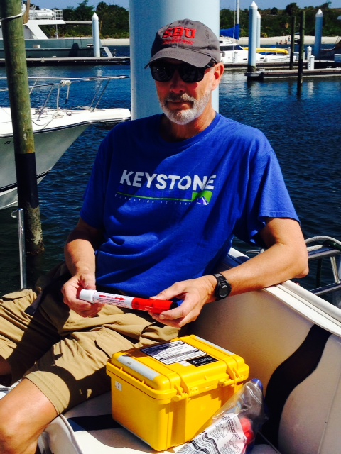
Paul is checking the expiration date on our on-board flares to make sure they are still current. The yellow box on the seat contains an EPIRB, which I rented from BoatUS for the duration of our trip to and from the Bahamas. When activated in the case of an accident, either manually or automatically if it becomes submerged in seawater, it will transmit an emergency call to the Coast Guard, including the details of the vessel and the exact location at the time of activation. I do not expect to need either of these devises, but we took these safety precautions just in case.
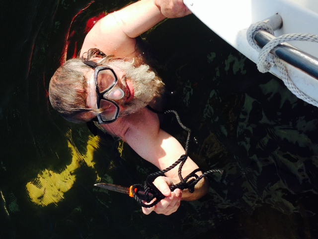
The afternoon before we left, I notices a piece of rope beneath the boat near the starboard propeller. Pulling on it failed to free it up, so I had to dive under the boat – sure enough, it was wound around the propeller and I had to cut it off with a knife.
Our wait started on Monday (March 2), and we were fortunate to get a short but favorable window on the following Friday, March 6 (people sometimes wait for weeks to get across during the winter months). The wind was forecast to be favorable early in the morning, but shift to the northeast by noon. So we set our alarms for 5:15 AM and cast off before 6:00 in the dark. We set a course due East for the West End of Grand Bahama Island, 65 miles away. Our planning and patience paid off – the wind was non-existent and the sea was calm for us, once we got a bit past the turbulence of the inlet from the ICW to the open ocean. By 11:30 AM we were tied up at the West End:

The Gulf Stream! The take-away from this photo is how unremarkable the sea looks – reflecting our good fortune to get a very calm, windless day to cross the Stream.
So – our crossing makes for a boring story, which is exactly the way we wanted it!
When entering the port of entry in the Bahamas, a vessel must fly a yellow “quarantine” flag until it has cleared customs. It is also customary, but not required, to fly a “courtesy flag” of the country which is being entered (you may recall that I embarrassed myself by inadvertently hanging the Canadian courtesy flag upside down when we entered Canada last Spring). We did better this time:
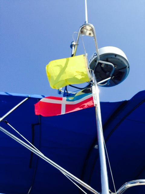
The yellow quarantine flag and the Bahamas courtesy flag on the Joint Adventure as we entered the West End
In the picture below, the large yellow form in the upper right corner is the southeastern part of the Florida peninsula. The large yellow and orange form at the bottom is Cuba. All of the rest of the yellow forms and dots form the Bahamas – some 1500 miles long. The whitish-blue are the Bahama banks – shallow water ranging from a few feet to seldom more than 15 feet deep. The Bahama banks are surrounded by water thousands of feet deep – in fact, upon approaching Grand Bahama Island, the water depth went from over a thousand feet deep to 15 feet in less than a mile! The abrupt change in depth is why the Bahamas is world renowned for big game sport fishing.
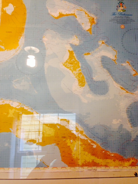
The Bahamas
Back to the map – Grand Bahama Island is the northwestern-most island, and the West End is at the western tip of that island – just 65 miles from the inlet at West Palm Beach. That’s where we crossed.
The West End consists of two different parts. Old Bahama Bay Marina is part of a resort at the tip of the island, which includes the amenities that you would expect of a resort – rental units, a sand beach, a fine restaurant, a tiki bar, small sailboats to rent, etc. A mile away is the West End Village where the local Bahamians live. Unfortunately, it is rural and poor – a lack of jobs and the devastating hurricane in 2004 has made it a difficult place to live. The people are resilient and friendly, however, and I met many of them during my frequent visits to the Village during the several days that I rode my bike into the Village to meet the people and explore. Here are some images from the West End of Grand Bahama Island:

The rental units at the resort, overlooking the harbor basin

The West End Village runs along the water, which is the focus of subsistence fishing by the residents. The primary focus is the harvesting of conch, which is done by diving in shallow water up to about 12 feet and picking them off the sandy ocean floor. No diving equipment is used – just masks while they hold their breath and dive.

I stopped to talk to this gentleman while he was removing the conch from the shells that he brought in that day. He showed me in detail how it is done and how the meat is then separated from the organs.
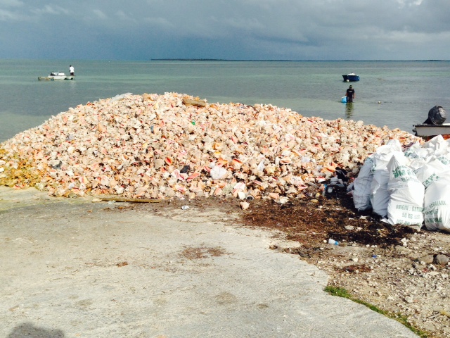
Along the shore of the West End Village are numerous piles like this one of empty conch shells from which the conch have been harvested and the shells discarded.

This swimmer near the shore is looking for conch or spiney lobster or anything else of value that he can find and catch on the ocean floor. He is pulling the tub behind him as he goes – anything he gets is stored in the tub while he continues to hunt until he swims back to shore.
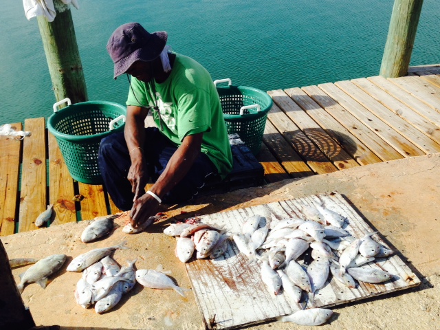
A subsistence fisherman cleaning his catch.

Located in the West End Village, this is the oldest hotel in the Bahamas. Today only the bar is open, and that seems to be only occasionally. I was told that the buildings behind the hotel contain tunnels running from building to building where bootleg liquor was hid and stored during Prohibition pending distribution to the US by bootleggers, which purportedly included an operation run by Joseph Kennedy.

This is probably my favorite picture from the entire trip. In many of the rural villages in the Bahamas, there is a woman who bakes and sells fresh bread. I went looking for her and asked this guy if he knew where she lived. After he gave me directions, we exchanged compliments on each other’s beard and chatted for about 20 minutes. Although I could only understand about every other word due to his thick Creole accent, his smile reflects his totally joyful personality. We saw each other several times during our visit, and we always stopped to chat.

This is Effie’s house – I knocked on her door and bought a loaf of fresh coconut bread and a coconut/pineapple pastry, somewhat like a pie. Yummy!

I asked if there was someplace in the Village where I could get ice cream – I was sent to this home where a woman named Lori lives. She goes to Freeport every two weeks or so and brings back a few tubs of ice cream which she sells from her house for $1 for two large scoops. I visited every day. She also sews beautiful hand-made dresses which she sells from her home as well.

We also went to Freeport and to Port Lucaya for a couple of days. There is virtually nothing to see in Freeport. About 10 years ago, the large hotel/casino closed, and the tourists on cruise ships arriving in Freeport Harbor are now bussed directly to Port Lucaya, which has a pleasant beach, some resort hotels, and a marketplace somewhat analogous to the Fanueil Hall marketplace in Boston (without the historic character). This photo is of the virtually abandoned “international marketplace” in Freeport, which withered away when the hotel/casino closed and tourists were bussed to Port Lucaya.
Paul left at the end of our stay in the West End, and Trish, my daughter Jenny, and her boyfriend Chris flew into Freeport to start our journey into the Abacos and the outer cays. More to come!
