Post #25: CHICAGO!! Day 112; August 23, 2014. On board: Paul, Jim K
“On a cold day in January 1900, a group of prominent Chicagoans gathered quietly at an earthen dam. The crowd, which started out as a few friends and trusted newspapermen, grew to about 100 as the men, trustees of the Chicago Sanitary and Ship Canal, broke through the ice and dirt separating the Mississippi and Great Lakes watersheds. They labored with dynamite, shovels, and a large dredge, keeping an eye out for the arrival of a threatened injunction from the Supreme Court. In the end, the water arrived before the litigation. They had reversed the flow of the Chicago River.”
Thus changed the course of geologic history. When the last of the glaciers retreated 10,000 years ago, the topography that they left behind had created two separate, enormous watersheds draining much of North America – the Great Lakes watershed, in which water from as far away as the Continental Divide would eventually find its way to the North Atlantic via the St. Lawrence River, and the Mississippi River Watershed, in which water from the vast midesection of America would eventually find its way to the Gulf of Mexico. By reversing the flow of the Chicago River, mankind had connected these two great watersheds which had been separate for 10,000 years. The feat was designated fifty years later by the American Society of Civil Engineers to be one of the seven modern wonders of the world. Freighters, barges, and recreational boaters could now enter the entire Great Lakes Watershed from New Orleans and vice versa – a connection which continues to move millions of tons of freight every year and is vital to the economy. In fact, without this connection between the watersheds, the Great Loop voyage would be impossible.
However, the Law of Unintended Consequences has created a potential environmental disaster – the spread of invasive species from one watershed to the other. In 2002, an electrical barrier was constructed downstream from Chicago to stop an invasive fish, the round goby, from spreading from the Great Lakes into the Mississippi watershed. The electrical barrier was too late, however, as it was later discovered that the round goby had established itself in the Mississippi watershed three years earlier. Now a more serious threat faces the Great Lakes from the Mississippi – the Asian carp, which has been destroying aquatic ecosystems on the Mississippi for the past 10 years. The Army Corp of Engineers has undertaken a massive, years-long study (the “Great Lakes Mississippi River Interbasin Study”) to determine how to solve the problem. Potential permanent solutions range from cutting the link once and for all and thereby permanently restoring separate watersheds, to installing from one to five barriers, including a system to lift boats over the barriers. Lifting recreational boats is doable, as evidenced by the Big Chute Marine Railway on the Trent Severn Waterway, but the great challenge would be lifting large freighters and other commercial vessels. The cost has been estimated as high as $9.5 billion (we veterans of the Big Dig know how good these early estimates are….); completion is unlikely before 2029 – by then, many people believe that temporary measures would be inadequate and the Asian Carp will have already made it into the Great Lakes with disastrous effects on boating, fishing, and recreation. Even if the waterways are separated or a barrier is constructed, there are other ways the Asian carp might get through – besides human activities, the Army Corp has identified 18 locations where floodwaters could allow carp to reach the lake. Several of those are identified as “medium risk”, meaning that an invasion is likely within 50 years.
In the meantime, we are grateful for the waterway connection or we wouldn’t now be in Chicago! Our final push started Monday morning with a short run to Grand Haven, Michigan, a medium-sized upscale tourist destination with many boutiques, galleries, gift shops, and restaurants. Like most of the cities and towns along the eastern shore of Michigan, Grand Haven was founded and grew from the fur trading and lumber harvesting businesses. However, Grand Haven had a distinct advantage – it is located at the mouth of the Grand River, at 260 miles the longest river in Michigan. Today it is navigable all the way to Grand Rapids, 40 miles upstream – the harbor therefore handles large commercial vessels heading upriver. In the 1800’s, Grand Haven became one of the largest manufacturers of furniture in the United States, being nicknamed “Furniture City.
In addition to the many shops, there are two interesting museums in town, and every evening during the summer, the town puts on a remarkable 20 minute fountain and light show on the opposite bank of the Grand River. Grand Haven is also home to a large Coast Guard station, and holds a town-wide celebration of its close relationship with the coast Guard every August. Here are some pictures from Grand Haven:

The lighthouse marking the entrance to Grand Haven harbor
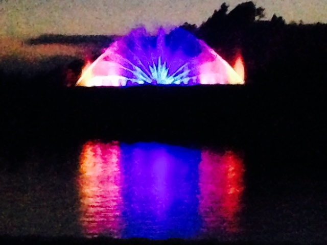
A view of the very professional light & fountain show across the Grand River – we were docked at the Municipal Marina right next to downtown and across from the light show, which we could watch from the bridge of the boat. The show is so popular that the town erected a grandstand on the waterfront directly across from the show. The fountain is nearly a football field long and contains 1300 nozzles (many of which fluctuate creating motion), 1.5 miles of pipe, nearly 4 miles of electrical cable, and shoots water 15 stories into the air!
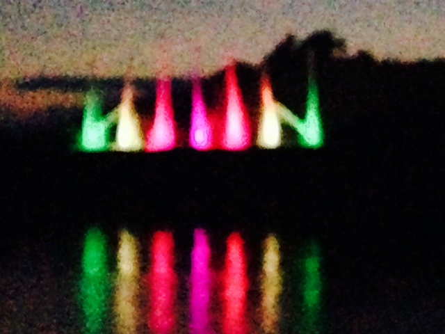
Another view of the show
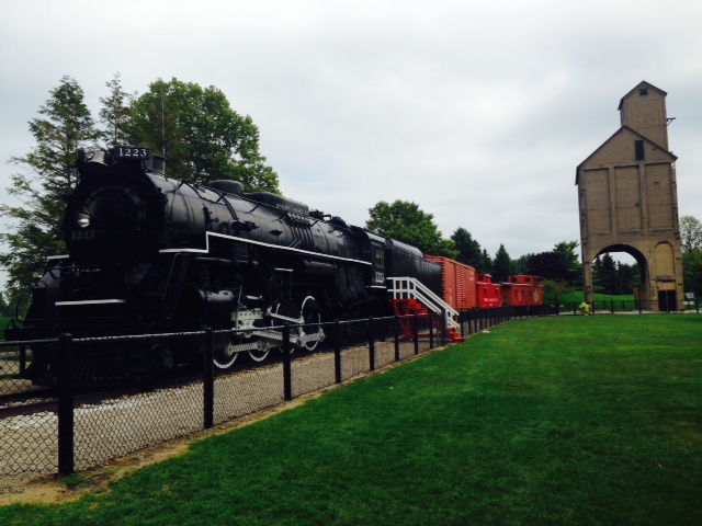
This coal-fired locomotive (with associated cars) is on display on the waterfront. It was built in 1941, then retired as obsolete just 10 years later. The building in the background is a coal elevator which was used to load coal onto the train

The Escanaba has a personal interest for Trish and her family – her uncle was stationed on the Escanaba in World War II and was lost at sea when she was sunk. When boating in Boston Harbor, we frequently pass Escanaba III which is docked at the Boston Coast Guard Station downtown and think of her uncle
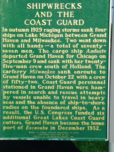
This historical marker shows how treacherous Lake Michigan and the Great Lakes can be in storms, especially in the fall and winter (which is one reason we’ll be off Lake Michigan by September 1). You may recall the song “The wreck of the Edmund Fitzgerald” by Gordon Lightfoot. The 729 foot Edmund Fitzgerald hauled iron ore from the mines near Duluth, Minnesota to Detroit, Toledo, and other Great Lakes ports for 17 years – she set seasonal haul records 6 times, often breaking her own record. However, on November 9, 1975, carrying a full load of ore, she was caught on Lake Superior in a violent storm with hurricane-force winds and waves up to 35 feet. Shortly after 7:00 PM the next day, she suddenly sank without sending out a distress signal, leading many to believe she suffered sudden catastrophic structural damage. All hands were lost and no bodies were ever recovered. The disaster lead to many safety requirements being implemented, including mandatory survival suits, depth finders, positioning systems, increased freeboard, and more frequent inspections
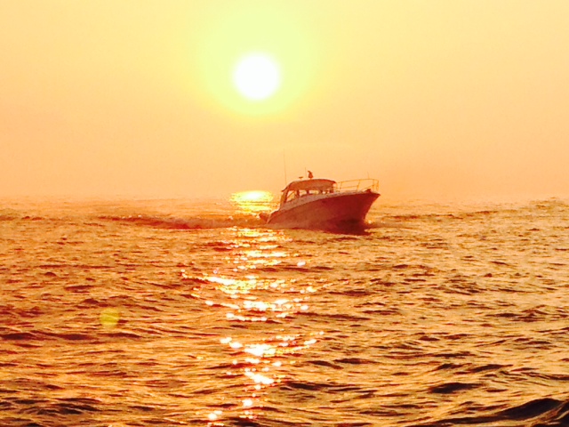
This is a boat coming into Grand Haven harbor at sunset
From Grand Haven, we ran about 35 miles to Saugatuck, another upscale resort-type village about a mile up the Kalamazoo River along the Michigan shore. It is an artsy community with many galleries and shops along several bustling streets crowded with pedestrians. The riverfront is gorgeous, with waterfront restaurants, dockages, and parks. The Saugatuck Center for the Arts is a performing arts theater, and we were lucky to learn that, due to a cancelation, there were two front row center seats available for the performance of “Beehive” that evening – a 60’s musical revue cast partly in New York. It was terrific – if you get a chance to see it somewhere, I highly recommend it!.
Here are a few pictures from Saugatuck:

A portion of the riverfront in Saugatuck
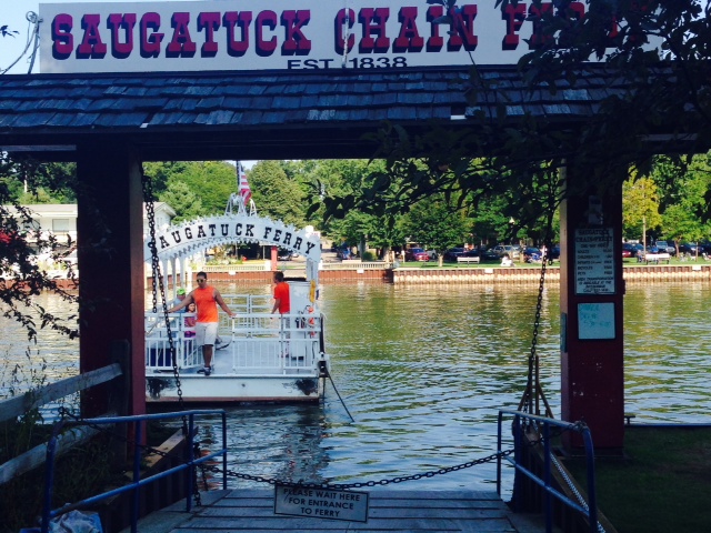
Saugutuck has a chain ferry that will take you across the river on demand – the ferry is literally connected to a chain that rests on the bottom and is attached to the ferry dock on each side. The operator (a college student) turns a crank on the ferry by hand, which pulls the ferry along the chain from one side to the other. It costs $1 – bikes are free!
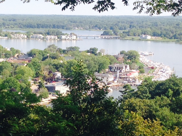
On the other side of the river, a 300-step climb up a set of stairs will get you to the top of Mt. Baldi, with an observation deck overlooking the village. The Joint Adventure is among the boats docked along the riverfront on the right-hand side of the picture
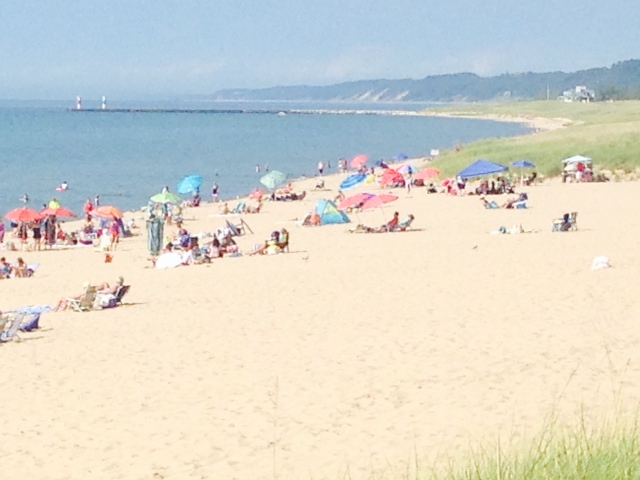
The beach at Saugatuck – typical of the beaches all along the shoreline of Michigan. Notice the twin breakwaters marking the harbor entrance in the background. The water here was noticeably warmer than further north
We had two more days to get to Chicago by Friday – Paul had a flight to Tampa on Saturday morning to visit his Dad, and my son Danny, currently living in Ann Arbor, is coming to visit in Chicago over the weekend. Thunderstorms were predicted for both Thursday and Friday, so on Thursday morning we were up before daybreak analyzing various weather reports to determine our best and safest option. We therefore decided to leave at first light and head 95 miles directly across Lake Michigan to Chicago. It took us 7 hours, at one point being about 45 miles from the nearest landfall. The wind was 5-10 knots on our bow, and at one point we had to slow our speed for a ride which was more comfortable for us and the boat, though we were trying to arrive as early as possible to beat the predicted thunderstorms. Five minutes after we reached Chicago and tied up, it started to rain!
A few final thoughts about our time in Michigan. What a great place! The run along the Michigan shoreline, about 350 miles, far exceeded our expectations, with incredible scenery, enormous dunes, fabulous sand beaches at every stop, and beautiful, well-kept, interesting towns along the way, each with its own special history and character. For the most part, we had beautiful, warm weather, and one or more of us went swimming on average about 4-5 days out of each 7 that were in Michigan. I do have to say that the water was quite cold on the northern half, but moderated noticeably on the southern half. The people of Michigan are friendly, outgoing, and always willing to help. If someone is looking for an interesting place to vacation, whether by boat or on land, the Michigan shoreline would be a wonderful place to do so.
CHICAGO! A MAJOR milestone on our Great Loop voyage. Here are some pictures as we approached Chicago:
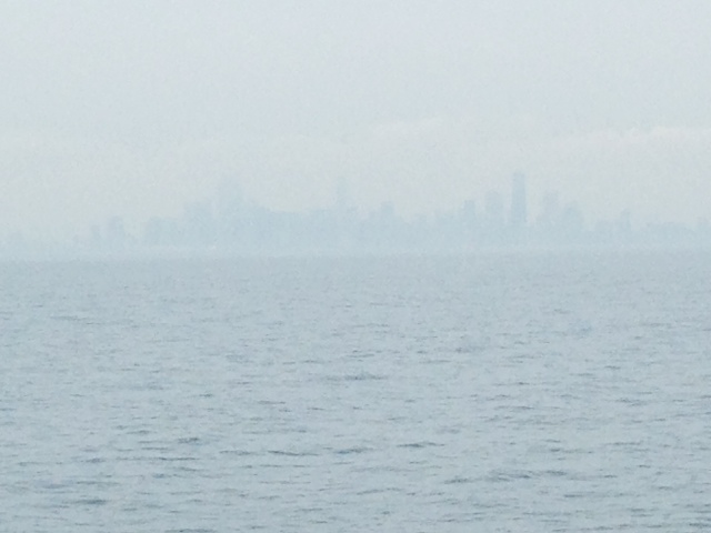
It was hazy, hot, and humid as we approached Chicago – this picture was taken from about 5 miles out – if you look closely, you’ll see the Chicago skyline
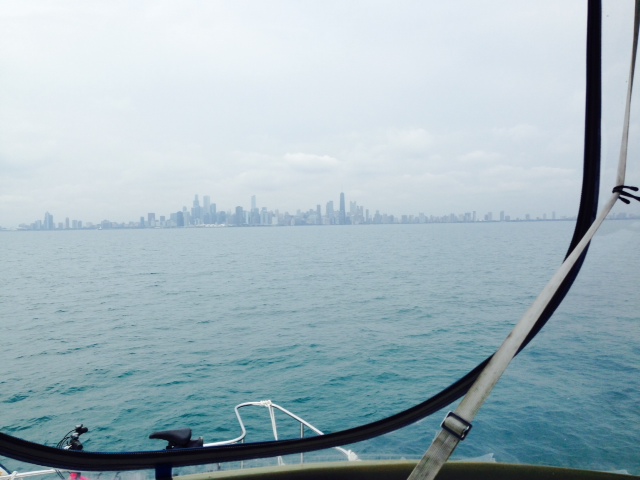
This picture was taken from about 3 miles out –

We’re now about a mile from the breakwater that serves as the entrance to Chicago’s main harbor

Almost there!!!
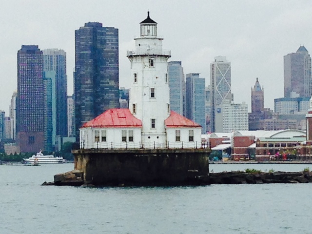
The iconic lighthouse marking the entrance to the harbor – we made it!!
The rivers, quirky canals, and small lakes that brought us from New York to Lake Huron are behind us, as are transiting the last of the Great Lakes. The next 1300 miles or so to Mobile, Alabama will be very different, as we transit the great inland rivers which are marked by currents, fluctuating water levels based on rainfall hundreds of miles away, commercial traffic, isolated stretches, and fewer facilities for recreational vessels. We also anticipate beautiful scenery, fascinating river towns, heartland cities, and interesting people as we pass through Illinois, Missouri, Kentucky, Tennessee, Mississippi, and Alabama. An adventure indeed!

only two people on board, must be time to do some more laundry.